
Thank you for supporting this site ❤️
Make a donation
Make a donation
Hindupur topographic map
Click on the map to display elevation.
Thank you for supporting this site ❤️
Make a donation
Make a donation
Hindupur
Even in summers, the city experiences lower temperatures compared to the rest of the state due to its high elevation. Every Year, The lowest temperature will be around 3 degrees and highest temperature will be around 11 degrees. Average annual rainfall is 551mm.
Thank you for supporting this site ❤️
Make a donation
Make a donation
About this map
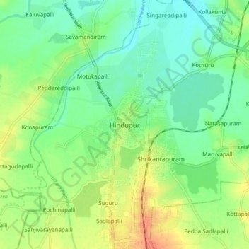
Name: Hindupur topographic map, elevation, terrain.
Location: Hindupur, Sri Sathya Sai, Andhra Pradesh, 515200, India (13.79061 77.45264 13.87061 77.53264)
Average elevation: 623 m
Minimum elevation: 607 m
Maximum elevation: 647 m
Thank you for supporting this site ❤️
Make a donation
Make a donation