
Thank you for supporting this site ❤️
Make a donation
Make a donation
Zenica topographic map
Click on the map to display elevation.
Thank you for supporting this site ❤️
Make a donation
Make a donation
Zenica
The city is geographically located in the heart of Bosnia. The settled area is 43.01 km2 (16.61 sq mi) and of the city proper covers 558.5 km2 (215.6 sq mi). Elevation is 310–350 m (1,017–1,148 ft). The rivers Bosna, Lašva, Babina, and Kočeva flow through the settlement. A moderate continental climate prevails. The city has thirteen urban local settlements and it consists of a total of 81 rural settlements.
Thank you for supporting this site ❤️
Make a donation
Make a donation
About this map
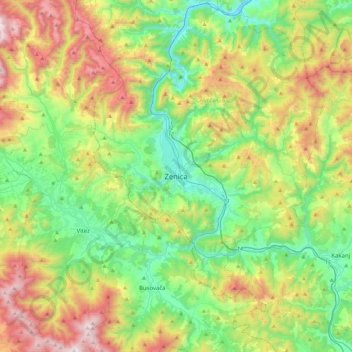
Name: Zenica topographic map, elevation, terrain.
Average elevation: 730 m
Minimum elevation: 251 m
Maximum elevation: 1,663 m
Thank you for supporting this site ❤️
Make a donation
Make a donation