
Thank you for supporting this site ❤️
Make a donation
Make a donation
Straitsville topographic map
Click on the map to display elevation.
Thank you for supporting this site ❤️
Make a donation
Make a donation
About this map
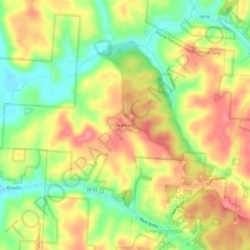
Name: Straitsville topographic map, elevation, terrain.
Location: Straitsville, Perry County, Ohio, 43766, United States (39.57479 -82.26570 39.61479 -82.22570)
Average elevation: 267 m
Minimum elevation: 218 m
Maximum elevation: 312 m
Thank you for supporting this site ❤️
Make a donation
Make a donation
Other topographic maps
Click on a map to view its topography, its elevation and its terrain.
Thank you for supporting this site ❤️
Make a donation
Make a donation
Thank you for supporting this site ❤️
Make a donation
Make a donation