
Thank you for supporting this site ❤️
Make a donation
Make a donation
Poucet topographic map
Click on the map to display elevation.
Thank you for supporting this site ❤️
Make a donation
Make a donation
About this map
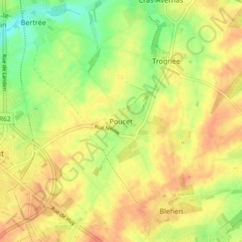
Name: Poucet topographic map, elevation, terrain.
Location: Poucet, Hannut, Waremme, Liège, Wallonie, 4280, Belgique (50.65778 5.09243 50.69778 5.13243)
Average elevation: 136 m
Minimum elevation: 112 m
Maximum elevation: 150 m
Thank you for supporting this site ❤️
Make a donation
Make a donation
Other topographic maps
Click on a map to view its topography, its elevation and its terrain.