
Thatcham topographic map
Interactive map
Click on the map to display elevation.
About this map
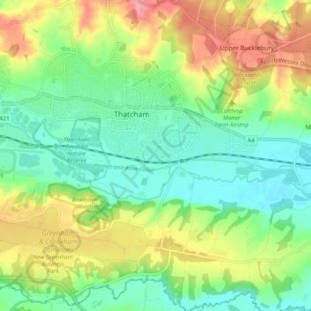
Name: Thatcham topographic map, elevation, terrain.
Location: Thatcham, West Berkshire, England, United Kingdom (51.36623 -1.29598 51.42332 -1.20907)
Average elevation: 94 m
Minimum elevation: 58 m
Maximum elevation: 152 m
Other topographic maps
Click on a map to view its topography, its elevation and its terrain.
Crookham Common
United Kingdom > England > West Berkshire > Thatcham
Crookham Common, Thatcham, West Berkshire, England, RG19 8DD, United Kingdom
Average elevation: 98 m