
Thank you for supporting this site ❤️
Make a donation
Make a donation
Rumendingen topographic map
Click on the map to display elevation.
Thank you for supporting this site ❤️
Make a donation
Make a donation
About this map
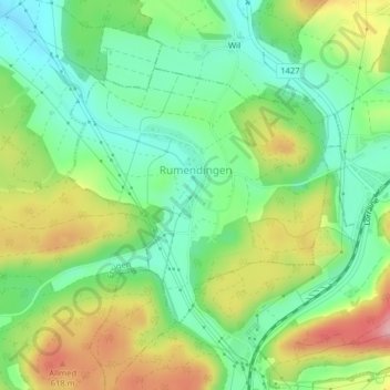
Name: Rumendingen topographic map, elevation, terrain.
Average elevation: 555 m
Minimum elevation: 495 m
Maximum elevation: 651 m
Thank you for supporting this site ❤️
Make a donation
Make a donation
Other topographic maps
Click on a map to view its topography, its elevation and its terrain.
Häusernmoos
Suisse > Berne > Arrondissement administratif de l'Emmental > Affoltern im Emmental
Average elevation: 763 m
Gmünde
Suisse > Berne > Arrondissement administratif de l'Emmental > Langnau im Emmental
Average elevation: 1,013 m
Horn
Suisse > Berne > Arrondissement administratif de l'Emmental > Dürrenroth
Average elevation: 802 m