
Thank you for supporting this site ❤️
Make a donation
Make a donation
Kut Chiang Mi topographic map
Click on the map to display elevation.
Thank you for supporting this site ❤️
Make a donation
Make a donation
About this map
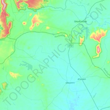
Name: Kut Chiang Mi topographic map, elevation, terrain.
Location: Kut Chiang Mi, Yasothon Province, Thailand (16.11682 104.31229 16.43682 104.63229)
Average elevation: 192 m
Minimum elevation: 141 m
Maximum elevation: 512 m
Thank you for supporting this site ❤️
Make a donation
Make a donation