
Thank you for supporting this site ❤️
Make a donation
Make a donation
Langley topographic map
Click on the map to display elevation.
Thank you for supporting this site ❤️
Make a donation
Make a donation
About this map
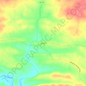
Name: Langley topographic map, elevation, terrain.
Location: Langley, Pike County, Arkansas, 71952, United States (34.29288 -93.86186 34.33288 -93.82186)
Average elevation: 245 m
Minimum elevation: 203 m
Maximum elevation: 289 m
Thank you for supporting this site ❤️
Make a donation
Make a donation
Other topographic maps
Click on a map to view its topography, its elevation and its terrain.
Crater of Diamonds State Park
United States > Arkansas > Pike County > Murfreesboro > Kimberley
Average elevation: 106 m
Thank you for supporting this site ❤️
Make a donation
Make a donation