
Thank you for supporting this site ❤️
Make a donation
Make a donation
Punta Majagual topographic map
Click on the map to display elevation.
Thank you for supporting this site ❤️
Make a donation
Make a donation
About this map
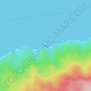
Name: Punta Majagual topographic map, elevation, terrain.
Average elevation: 55 m
Minimum elevation: 0 m
Maximum elevation: 235 m
Thank you for supporting this site ❤️
Make a donation
Make a donation
Other topographic maps
Click on a map to view its topography, its elevation and its terrain.
Río Capaya
Venezuela > Estado Miranda > Municipio Brión > Parroquia Higuerote > Boca Vieja
Average elevation: 3 m