
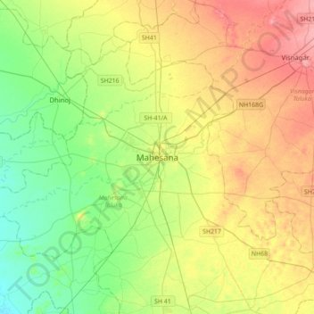
Mahesana topographic map
Interactive map
Click on the map to display elevation.
About this map
Name: Mahesana topographic map, elevation, terrain.
Average elevation: 92 m
Minimum elevation: 59 m
Maximum elevation: 138 m
Mehsana has an average elevation of 375 feet (114 m) above sea level. By Ahmedabad-Palnpur Railway line, the town is divided in two: the east and western parts are known as Mehsana-1 and Mehsana-2 respectively.
Other topographic maps
Click on a map to view its topography, its elevation and its terrain.
Simandhar Tenements & Flats
India > Gujarat > Mahesana Taluka
Simandhar Tenements & Flats, Mahesana Taluka, Mahesana District, Gujarat, 384001, India
Average elevation: 87 m