
Make a donation
Elbląg topographic map
Click on the map to display elevation.
Make a donation
Elbląg
The modern city adjoins about half the length of the river between Lake Drużno and Elbląg Bay (Zatoka Elbląska, an arm of the Vistula Lagoon), and spreads out on both banks, though mainly on the eastern side. To the east is the Elbląg Upland (Wysoczyzna Elbląska), a dome pushed up by glacial compression, 390 km2 in diameter and 200 m (656.17 ft) high at its greatest elevation.
Make a donation
About this map
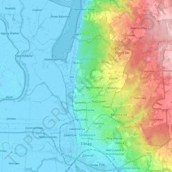
Name: Elbląg topographic map, elevation, terrain.
Location: Elbląg, Warmian-Masurian Voivodeship, Poland (54.13445 19.35901 54.26326 19.50969)
Average elevation: 49 m
Minimum elevation: -6 m
Maximum elevation: 193 m
Make a donation
Other topographic maps
Click on a map to view its topography, its elevation and its terrain.
Make a donation
Make a donation
Make a donation
Make a donation
Masurian Lake District
Poland > Warmian-Masurian Voivodeship > Mrągowo County
Average elevation: 110 m
Make a donation
Make a donation
Make a donation
Make a donation
Make a donation
Make a donation
Dylewska Góra
Poland > Warmian-Masurian Voivodeship > Ostróda County > Wysoka Wieś
Dylewska Góra (German: Kernsdorfer Höhe) is a hill located in northeastern Poland, south of the town of Ostróda, in the Warmian-Masurian Voivodeship. With elevation of 312 metres above sea level, it is one of the highest points of northern and central Poland. Dylewska Góra is a morainic hill, with its…
Average elevation: 269 m
Rodowo
Poland > Warmian-Masurian Voivodeship > Mrągowo County > Jędrychowo > Rodowo
Average elevation: 162 m
Make a donation