
Malinka topographic map
Interactive map
Click on the map to display elevation.
About this map
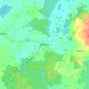
Name: Malinka topographic map, elevation, terrain.
Average elevation: 146 m
Minimum elevation: 130 m
Maximum elevation: 188 m
Other topographic maps
Click on a map to view its topography, its elevation and its terrain.
Orło
Poland > Warmian-Masurian Voivodeship > Giżycko County
Orło, gmina Ryn, Giżycko County, Warmian-Masurian Voivodeship, 11-520, Poland
Average elevation: 142 m
Jezioro Ołów
Poland > Warmian-Masurian Voivodeship > Giżycko County > Ryn
Jezioro Ołów, Ryn, gmina Ryn, Giżycko County, Warmian-Masurian Voivodeship, Poland
Average elevation: 131 m
Bystry
Poland > Warmian-Masurian Voivodeship > Giżycko County
Bystry, gmina Giżycko, Giżycko County, Warmian-Masurian Voivodeship, 11-500, Poland
Average elevation: 126 m
Ryn
Poland > Warmian-Masurian Voivodeship > Giżycko County
Ryn, gmina Ryn, Giżycko County, Warmian-Masurian Voivodeship, Poland
Average elevation: 132 m
Kisajno
Poland > Warmian-Masurian Voivodeship > Giżycko County > Piękna Góra
Kisajno, Piękna Góra, gmina Giżycko, Giżycko County, Warmian-Masurian Voivodeship, 11-500, Poland
Average elevation: 120 m
Dejguny
Poland > Warmian-Masurian Voivodeship > Giżycko County > Sterławki Małe
Dejguny, Sterławki Małe, gmina Giżycko, Giżycko County, Warmian-Masurian Voivodeship, Poland
Average elevation: 122 m
Giżycko
Poland > Warmian-Masurian Voivodeship > Giżycko County
Giżycko, Giżycko County, Warmian-Masurian Voivodeship, 11-500, Poland
Average elevation: 125 m