
Make a donation
Rohrsee topographic map
Click on the map to display elevation.
Make a donation
About this map
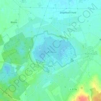
Name: Rohrsee topographic map, elevation, terrain.
Average elevation: 672 m
Minimum elevation: 659 m
Maximum elevation: 717 m
Make a donation
Other topographic maps
Click on a map to view its topography, its elevation and its terrain.
Steinental
Deutschland > Baden-Württemberg > Landkreis Ravensburg > Bad Wurzach
Average elevation: 697 m
Dietrichsholz
Deutschland > Baden-Württemberg > Landkreis Ravensburg > Bad Wurzach
Average elevation: 682 m
Seibranz
Deutschland > Baden-Württemberg > Landkreis Ravensburg > Bad Wurzach
Average elevation: 737 m
Make a donation
Starkenhofen
Deutschland > Baden-Württemberg > Landkreis Ravensburg > Bad Wurzach
Average elevation: 732 m
Seibranz-Ösch
Deutschland > Baden-Württemberg > Landkreis Ravensburg > Bad Wurzach
Average elevation: 732 m
Wengenreute
Deutschland > Baden-Württemberg > Landkreis Ravensburg > Bad Wurzach > Seibranz
Average elevation: 719 m
Make a donation
Rohrsee
Deutschland > Baden-Württemberg > Landkreis Ravensburg > Bad Wurzach > Eintürnen
Das rund 110 Hektar große Naturschutzgebiet „Rohrsee“ gehört zum Westallgäuer Hügelland. Es liegt auf einer durchschnittlichen Höhe von 667 m ü. NN, rund sechs Kilometer südwestlich der Stadtmitte Bad Wurzachs, zwischen den Ortsteilen Rohrbach im Osten und Rohr im Süden sowie dem zu Wolfegg…
Average elevation: 673 m