
Thank you for supporting this site ❤️
Make a donation
Make a donation
The Pinnacles topographic map
Click on the map to display elevation.
Thank you for supporting this site ❤️
Make a donation
Make a donation
About this map
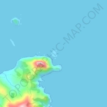
Name: The Pinnacles topographic map, elevation, terrain.
Location: The Pinnacles, Waikato, New Zealand (-36.47095 175.41244 -36.46917 175.41451)
Average elevation: 14 m
Minimum elevation: 0 m
Maximum elevation: 206 m
Thank you for supporting this site ❤️
Make a donation
Make a donation
Other topographic maps
Click on a map to view its topography, its elevation and its terrain.
Thank you for supporting this site ❤️
Make a donation
Make a donation
Māhoenui
New Zealand > Waikato > Waitomo District
Māhoenui is located in the King Country approx 50 kilometres (31 mi) inland from the west coast of the North Island, the topography is hilly to mountainous, with small alluvial areas near the streams and river.
Average elevation: 113 m
Thank you for supporting this site ❤️
Make a donation
Make a donation
Thank you for supporting this site ❤️
Make a donation
Make a donation
Thank you for supporting this site ❤️
Make a donation
Make a donation
Thank you for supporting this site ❤️
Make a donation
Make a donation
Thank you for supporting this site ❤️
Make a donation
Make a donation
Kuranui
New Zealand > Waikato > Matamata Piako District > Morrinsville > Kuranui
Average elevation: 43 m
Thank you for supporting this site ❤️
Make a donation
Make a donation