
Gießen topographic map
Interactive map
Click on the map to display elevation.
About this map
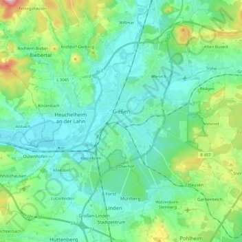
Name: Gießen topographic map, elevation, terrain.
Location: Gießen, Landkreis Gießen, Hessen, Duitsland (50.52633 8.55574 50.63522 8.76419)
Average elevation: 204 m
Minimum elevation: 147 m
Maximum elevation: 411 m
Other topographic maps
Click on a map to view its topography, its elevation and its terrain.
Hungen
Duitsland > Hessen > Landkreis Gießen
Hungen, Landkreis Gießen, Hessen, 35410, Duitsland
Average elevation: 160 m
Heuchelheim
Duitsland > Hessen > Landkreis Gießen
Heuchelheim, Landkreis Gießen, Hessen, 35452, Duitsland
Average elevation: 175 m
Villingen
Duitsland > Hessen > Landkreis Gießen
Villingen, Hungen, Landkreis Gießen, Hessen, Duitsland
Average elevation: 193 m