
Thank you for supporting this site ❤️
Make a donation
Make a donation
Jaun topographic map
Click on the map to display elevation.
Thank you for supporting this site ❤️
Make a donation
Make a donation
Jaun
The municipality is located in the Gruyère district, in the Jaun pass at an elevation of 1,027 m (3,369 ft). It consists of the linear village of Jaun and the hamlets of Im Fang (French: La Villette), Kappelboden, Weibelsried, Zur Eich and a number of scattered farm houses.
Thank you for supporting this site ❤️
Make a donation
Make a donation
About this map
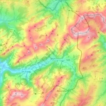
Name: Jaun topographic map, elevation, terrain.
Location: Jaun, Gruyère District, Fribourg, 1656, Switzerland (46.56340 7.19399 46.67004 7.32070)
Average elevation: 1,487 m
Minimum elevation: 885 m
Maximum elevation: 2,218 m
Thank you for supporting this site ❤️
Make a donation
Make a donation