
Thank you for supporting this site ❤️
Make a donation
Make a donation
Kamudooke topographic map
Click on the map to display elevation.
Thank you for supporting this site ❤️
Make a donation
Make a donation
About this map
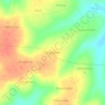
Name: Kamudooke topographic map, elevation, terrain.
Location: Kamudooke, Namutumba, Eastern Region, Uganda (0.92106 33.62441 0.96106 33.66441)
Average elevation: 1,086 m
Minimum elevation: 1,058 m
Maximum elevation: 1,109 m
Thank you for supporting this site ❤️
Make a donation
Make a donation