
Thank you for supporting this site ❤️
Make a donation
Make a donation
Westerholt topographic map
Click on the map to display elevation.
Thank you for supporting this site ❤️
Make a donation
Make a donation
About this map
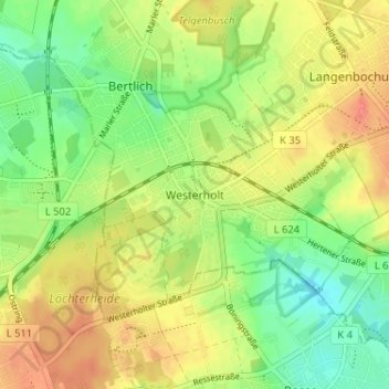
Name: Westerholt topographic map, elevation, terrain.
Average elevation: 73 m
Minimum elevation: 44 m
Maximum elevation: 105 m
Thank you for supporting this site ❤️
Make a donation
Make a donation
Other topographic maps
Click on a map to view its topography, its elevation and its terrain.
Bertlich
Deutschland > Nordrhein-Westfalen > Kreis Recklinghausen > Herten > Westerholt
Average elevation: 70 m
45701
Deutschland > Nordrhein-Westfalen > Kreis Recklinghausen > Herten > Westerholt
Average elevation: 75 m
Thank you for supporting this site ❤️
Make a donation
Make a donation
Bertlich
Deutschland > Nordrhein-Westfalen > Kreis Recklinghausen > Herten > Westerholt
Average elevation: 70 m