
Thank you for supporting this site ❤️
Make a donation
Make a donation
Campo Alegre topographic map
Click on the map to display elevation.
Thank you for supporting this site ❤️
Make a donation
Make a donation
About this map
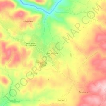
Name: Campo Alegre topographic map, elevation, terrain.
Location: Campo Alegre, Cordoue, Andalousie, Espagne (37.90554 -4.91175 37.94554 -4.87175)
Average elevation: 403 m
Minimum elevation: 254 m
Maximum elevation: 515 m
Thank you for supporting this site ❤️
Make a donation
Make a donation
Other topographic maps
Click on a map to view its topography, its elevation and its terrain.