
Thank you for supporting this site ❤️
Make a donation
Make a donation
Clichy topographic map
Click on the map to display elevation.
Thank you for supporting this site ❤️
Make a donation
Make a donation
About this map
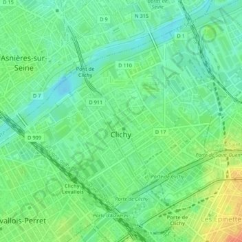
Name: Clichy topographic map, elevation, terrain.
Average elevation: 36 m
Minimum elevation: 21 m
Maximum elevation: 61 m
Thank you for supporting this site ❤️
Make a donation
Make a donation
Other topographic maps
Click on a map to view its topography, its elevation and its terrain.
Thank you for supporting this site ❤️
Make a donation
Make a donation
Clichy-la-Garenne
France > Hauts-de-Seine > Clichy-la-Garenne > Clichy-la-Garenne
Average elevation: 43 m
Neuilly-sur-Seine
France > Hauts-de-Seine > Neuilly-sur-Seine > Neuilly-sur-Seine
Average elevation: 46 m
Thank you for supporting this site ❤️
Make a donation
Make a donation
Thank you for supporting this site ❤️
Make a donation
Make a donation