
Make a donation
Roccatederighi topographic map
Click on the map to display elevation.
Make a donation
About this map
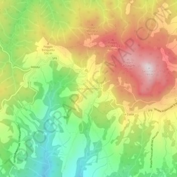
Name: Roccatederighi topographic map, elevation, terrain.
Location: Roccatederighi, Roccastrada, Grosseto, Tuscany, 58036, Italy (43.00831 11.06151 43.04831 11.10151)
Average elevation: 473 m
Minimum elevation: 192 m
Maximum elevation: 783 m
Make a donation
Other topographic maps
Click on a map to view its topography, its elevation and its terrain.
Seggiano
With the exception of units of low hill near the beds of rivers, the region extends mainly in hilly and mountainous odds, but good exposure allows the cultivation of a cultivar of olive, Olivastra Seggianese, called up to elevations of low mountains, managing to produce an oil of excellent quality.
Average elevation: 550 m
Make a donation
Make a donation
Pitigliano
The municipality area of Pitigliano, while presenting different local situations on the basis of 'topography is characterized by rather low winter temperatures, which can occur during prolonged periods, despite the daily maximum values are often pleasing. On the contrary, in summer the heat can be very…
Average elevation: 331 m
Make a donation