
Rotoroa Island topographic map
Interactive map
Click on the map to display elevation.
About this map
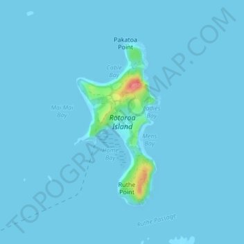
Name: Rotoroa Island topographic map, elevation, terrain.
Location: Rotoroa Island, Waiheke, Auckland, Nouvelle-Zélande (-36.82490 175.19084 -36.80623 175.20289)
Average elevation: 2 m
Minimum elevation: 0 m
Maximum elevation: 69 m
Other topographic maps
Click on a map to view its topography, its elevation and its terrain.
Rangitoto Island
Nouvelle-Zélande > Auckland > Waiheke
Rangitoto Island, Waiheke, Auckland, Nouvelle-Zélande
Average elevation: 30 m