
Ramapuram topographic map
Interactive map
Click on the map to display elevation.
About this map
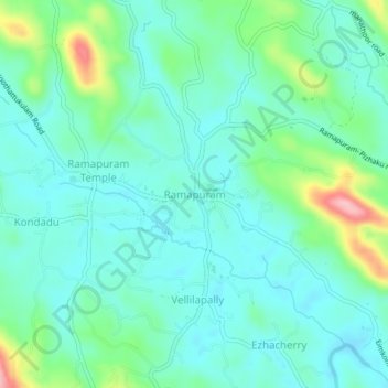
Name: Ramapuram topographic map, elevation, terrain.
Location: Ramapuram, Meenachil, Kottayam District, Kerala, 686576, India (9.78019 76.64211 9.82019 76.68211)
Average elevation: 60 m
Minimum elevation: 25 m
Maximum elevation: 179 m
Other topographic maps
Click on a map to view its topography, its elevation and its terrain.
Melukavu
India > Kerala > Meenachil > Melukavumattom
Melukavu, Melukavumattom, Meenachil, Kottayam District, Kerala, India
Average elevation: 599 m
Bharananganam
Bharananganam, Meenachil, Kottayam District, Kerala, 686578, India
Average elevation: 40 m
Kuravilangad
Kuravilangad, Meenachil, Kottayam, Kerala, 686633, India
Average elevation: 52 m
Erattupetta
Erattupetta, Meenachil, Kottayam, Kerala, 686122, India
Average elevation: 78 m
Pala Municipality Boarder with Mutholi Pachyath
Pala Municipality Boarder with Mutholi Pachyath, Meenachil, Kottayam, Kerala, 686574, India
Average elevation: 24 m
Pravithanam
Pravithanam, Meenachil, Kottayam District, Kerala, 686575, India
Average elevation: 58 m
Kurishumala
India > Kerala > Meenachil > Vazhikadavu
Kurishumala, Vazhikadavu, Meenachil, Kottayam District, Kerala, 685503, India
Average elevation: 862 m