
Thank you for supporting this site ❤️
Make a donation
Make a donation
Fayetteville topographic map
Click on the map to display elevation.
Thank you for supporting this site ❤️
Make a donation
Make a donation
About this map
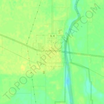
Name: Fayetteville topographic map, elevation, terrain.
Location: Fayetteville, Saint Clair County, Illinois, United States (38.37267 -89.80174 38.38154 -89.79131)
Average elevation: 124 m
Minimum elevation: 111 m
Maximum elevation: 132 m
Thank you for supporting this site ❤️
Make a donation
Make a donation
Other topographic maps
Click on a map to view its topography, its elevation and its terrain.
Thank you for supporting this site ❤️
Make a donation
Make a donation
Dutch Hollow
United States > Illinois > Saint Clair County > Belleville > Dutch Hollow
Average elevation: 170 m