
Thank you for supporting this site ❤️
Make a donation
Make a donation
Sala kommun topographic map
Click on the map to display elevation.
Thank you for supporting this site ❤️
Make a donation
Make a donation
About this map
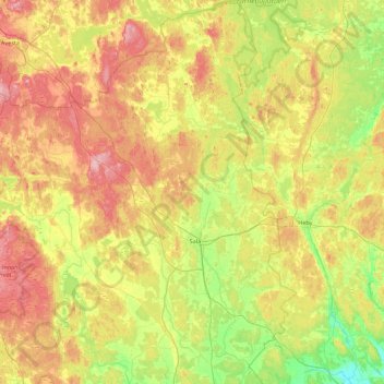
Name: Sala kommun topographic map, elevation, terrain.
Location: Sala kommun, Västmanland County, Sweden (59.75530 16.09240 60.19505 16.83704)
Average elevation: 72 m
Minimum elevation: 18 m
Maximum elevation: 144 m
Thank you for supporting this site ❤️
Make a donation
Make a donation
Other topographic maps
Click on a map to view its topography, its elevation and its terrain.
Västerås
Västerås is predominantly known as an industrial city, but also a retailing and logistics city. The city wants to distinguish itself as Västerås – Mälarstaden, meaning "Västerås—the city by Lake Mälaren", in order to attract tourists and new residents, as well as students to the local university,…
Average elevation: 28 m
Thank you for supporting this site ❤️
Make a donation
Make a donation
Thank you for supporting this site ❤️
Make a donation
Make a donation
Thank you for supporting this site ❤️
Make a donation
Make a donation