
Make a donation
Tublay topographic map
Click on the map to display elevation.
Make a donation
Tublay
According to the Philippine Statistics Authority, the municipality has a land area of 102.55 square kilometres (39.59 sq mi) constituting 3.70% of the 2,769.08-square-kilometre- (1,069.15 sq mi) total area of Benguet. The topography is generally mountainous with an elevation of 1,400 metres (4,600 ft) above sea level. It has two pronounced seasons - the dry and the wet seasons with a temperature coldest at 6.5 °C (43.7 °F) and warmest at 27.5 °C (81.5 °F). There are 2 seasons for Tublay, Benguet will be wet season from May to October and dry season from November to April.
Make a donation
About this map
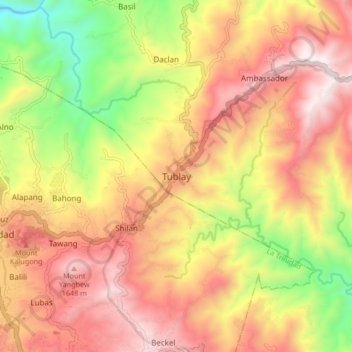
Name: Tublay topographic map, elevation, terrain.
Average elevation: 1,256 m
Minimum elevation: 617 m
Maximum elevation: 1,764 m
Make a donation
Other topographic maps
Click on a map to view its topography, its elevation and its terrain.
La Trinidad
The terrain is generally mountainous with springs, rivers and creeks. The town has a valley which encompasses several barangays. The valley floor elevation is at 1,300 metres (4,300 ft) above sea level. Elevation ranges from 500 to 1,700 metres (1,600 to 5,600 ft) above sea level.
Average elevation: 1,123 m
Wangal, La Trinidad, Benguet
Philippines > Benguet > La Trinidad > Wangal > Ampasit
Average elevation: 1,352 m
Make a donation
Ambuklao Dam
Philippines > Benguet > Ambuclao > Ambangol
SNAP-Benguet began a massive rehabilitation project that restored Ambuklao to operating status and increased its capacity from 75 MW to 105 MW. The project required the construction of a new intake, headrace and penstock, elevation of tailrace tunnel outlet, de-silting of tailrace tunnel and replacement of…
Average elevation: 808 m
La Trinidad
The terrain is generally mountainous with springs, rivers and creeks. The town has a valley which encompasses several barangays. The valley floor elevation is at 1,300 metres (4,300 ft) above sea level. Elevation ranges from 500 to 1,700 metres (1,600 to 5,600 ft) above sea level.
Average elevation: 1,123 m
Make a donation
Make a donation
La Trinidad
The terrain is generally mountainous with springs, rivers and creeks. The town has a valley which encompasses several barangays. The valley floor elevation is at 1,300 metres (4,300 ft) above sea level. Elevation ranges from 500 to 1,700 metres (1,600 to 5,600 ft) above sea level.
Average elevation: 1,123 m
Make a donation
La Trinidad
The terrain is generally mountainous with springs, rivers and creeks. The town has a valley which encompasses several barangays. The valley floor elevation is at 1,300 metres (4,300 ft) above sea level. Elevation ranges from 500 to 1,700 metres (1,600 to 5,600 ft) above sea level.
Average elevation: 1,123 m