
Make a donation
Authon topographic map
Click on the map to display elevation.
Make a donation
Authon
The village is located at an altitude of 1,137 metres above sea level in the Massif des Monges. The altitude varies from 881 metres (in the downstream gorges of the Vanson and the narrow valley in the west of the commune) to 2,114 metres at the top of Coste Belle along the Conaples ridge in the east. Mount Jouere is located in the north with the ridge of Clot des Martres being the northern boundary of the commune. The Planchettes ravine lies between this mountain and the Lieuron - the mountain overlooking the village.
Make a donation
About this map
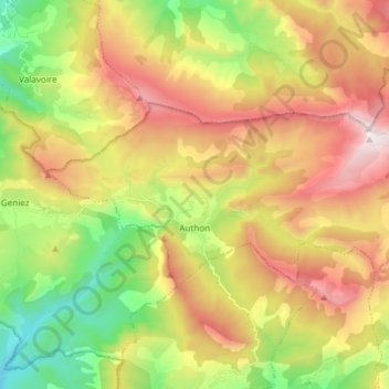
Name: Authon topographic map, elevation, terrain.
Average elevation: 1,304 m
Minimum elevation: 624 m
Maximum elevation: 2,113 m
Make a donation
Other topographic maps
Click on a map to view its topography, its elevation and its terrain.
Revest
France > Provence-Alpes-Côte d'Azur > Alpes-de-Haute-Provence > Malijai
Average elevation: 524 m
Molanès
France > Provence-Alpes-Côte d'Azur > Alpes-de-Haute-Provence > Uvernet-Fours
Average elevation: 1,566 m
Le Caravon
France > Provence-Alpes-Côte d'Azur > Alpes-de-Haute-Provence > Oppedette
Average elevation: 553 m
Chavailles
France > Provence-Alpes-Côte d'Azur > Alpes-de-Haute-Provence > Prads-Haute-Bléone
Average elevation: 1,491 m
Make a donation
La Croix
France > Provence-Alpes-Côte d'Azur > Alpes-de-Haute-Provence > Jausiers
Average elevation: 2,128 m
Mont d'Or
France > Provence-Alpes-Côte d'Azur > Alpes-de-Haute-Provence > Manosque
Average elevation: 394 m
Saint-Michel
France > Provence-Alpes-Côte d'Azur > Alpes-de-Haute-Provence > Moustiers-Sainte-Marie
Average elevation: 731 m
La Foux d'Allos
France > Provence-Alpes-Côte d'Azur > Alpes-de-Haute-Provence > Allos
Average elevation: 2,094 m
Make a donation
Colmars
France > Provence-Alpes-Côte d'Azur > Alpes-de-Haute-Provence > Colmars > Colmars
Average elevation: 1,565 m
Barcelonnette
France > Provence-Alpes-Côte d'Azur > Alpes-de-Haute-Provence > Barcelonnette > Barcelonnette
Barcelonnette is situated in the wide and fertile Ubaye Valley, of which it is the largest town. It lies at an elevation of 1132 m (3717 ft) on the right bank of the Ubaye River, and is surrounded by mountains which reach peaks of over 3000 m; the tallest of these is the Needle of Chambeyron at 3412 m.…
Average elevation: 1,494 m
Aurafrède
France > Provence-Alpes-Côte d'Azur > Alpes-de-Haute-Provence > Gréoux-les-Bains
Average elevation: 389 m
Brame-Faim
France > Provence-Alpes-Côte d'Azur > Alpes-de-Haute-Provence > Mirabeau
Average elevation: 624 m
Make a donation
Pont de la Serre
France > Provence-Alpes-Côte d'Azur > Alpes-de-Haute-Provence > Colmars
Average elevation: 1,990 m
La Colle Saint-Michel
France > Provence-Alpes-Côte d'Azur > Alpes-de-Haute-Provence > Thorame-Haute
Average elevation: 1,370 m