
Thank you for supporting this site ❤️
Make a donation
Make a donation
Tatra Mountains topographic map
Click on the map to display elevation.
Thank you for supporting this site ❤️
Make a donation
Make a donation
Tatra Mountains
The Tatras lie in the temperate zone of Central Europe. They are an important barrier to the movements of air masses. Their mountainous topography causes one of the most diverse climates in that region.
Thank you for supporting this site ❤️
Make a donation
Make a donation
About this map
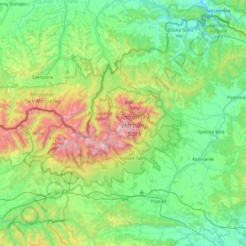
Name: Tatra Mountains topographic map, elevation, terrain.
Location: Tatra Mountains, Region of Prešov, Eastern Slovakia, Slovakia (49.13169 19.58516 49.28360 20.32012)
Average elevation: 1,001 m
Minimum elevation: 508 m
Maximum elevation: 2,611 m
Thank you for supporting this site ❤️
Make a donation
Make a donation