
Thank you for supporting this site ❤️
Make a donation
Make a donation
Frankenheim topographic map
Click on the map to display elevation.
Thank you for supporting this site ❤️
Make a donation
Make a donation
About this map
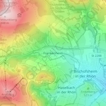
Name: Frankenheim topographic map, elevation, terrain.
Average elevation: 599 m
Minimum elevation: 421 m
Maximum elevation: 890 m
Thank you for supporting this site ❤️
Make a donation
Make a donation
Other topographic maps
Click on a map to view its topography, its elevation and its terrain.
97653
Deutschland > Bayern > Landkreis Rhön-Grabfeld > Bischofsheim in der Rhön
Average elevation: 615 m