
Ciénaga topographic map
Interactive map
Click on the map to display elevation.
About this map
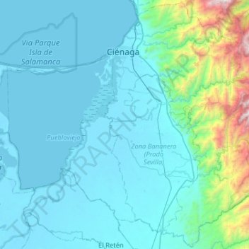
Name: Ciénaga topographic map, elevation, terrain.
Location: Ciénaga, Magdalena, Kolumbien (10.60808 -74.28476 11.10535 -73.76951)
Average elevation: 1,630 m
Minimum elevation: 4 m
Maximum elevation: 5,584 m
Other topographic maps
Click on a map to view its topography, its elevation and its terrain.
Ciénaga Grande De Santa Marta
Ciénaga Grande De Santa Marta, Sitionuevo, Magdalena, Kolumbien
Average elevation: 0 m