
Thank you for supporting this site ❤️
Make a donation
Make a donation
Monte Tamor topographic map
Click on the map to display elevation.
Thank you for supporting this site ❤️
Make a donation
Make a donation
About this map
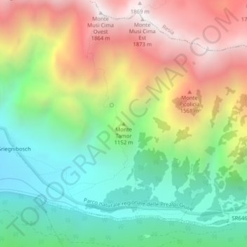
Name: Monte Tamor topographic map, elevation, terrain.
Location: Monte Tamor, Udine, Friaul-Julisch Venetien, Italien (46.31449 13.29797 46.31459 13.29807)
Average elevation: 1,109 m
Minimum elevation: 572 m
Maximum elevation: 1,840 m
Thank you for supporting this site ❤️
Make a donation
Make a donation
Other topographic maps
Click on a map to view its topography, its elevation and its terrain.
Kanaltal
Italien > Friaul-Julisch Venetien > Udine > Malborgeth-Wolfsbach
Das Kanaltal, italienisch Val Canale, furlanisch Val Cjanâl, slowenisch Kanalska dolina, ist eine zu Italien und teilweise zu Österreich gehörende, 23 km lange Talung im Dreiländereck Italien-Österreich-Slowenien mit dem Zentrum Tarvis. Das Kanaltal trennt die Karnischen von den Julischen Alpen und den…
Average elevation: 1,196 m