
Thank you for supporting this site ❤️
Make a donation
Make a donation
Central Region topographic map
Click on the map to display elevation.
Thank you for supporting this site ❤️
Make a donation
Make a donation
About this map
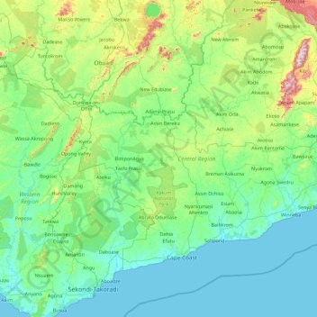
Name: Central Region topographic map, elevation, terrain.
Location: Central Region, Ghana (5.03343 -2.20525 6.29927 -0.40033)
Average elevation: 114 m
Minimum elevation: -1 m
Maximum elevation: 824 m
Thank you for supporting this site ❤️
Make a donation
Make a donation
Other topographic maps
Click on a map to view its topography, its elevation and its terrain.
Dzorwulu
Ghana > Greater Accra Region > Ayawaso West Municipal District > Accra > Dzorwulu
Average elevation: 46 m