
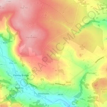
High and Low Bishopside topographic map
Interactive map
Click on the map to display elevation.
About this map
Name: High and Low Bishopside topographic map, elevation, terrain.
Average elevation: 248 m
Minimum elevation: 102 m
Maximum elevation: 382 m
Other topographic maps
Click on a map to view its topography, its elevation and its terrain.
Bishop Monkton
United Kingdom > England > Harrogate
Bishop Monkton, Harrogate, North Yorkshire, Yorkshire and the Humber, England, United Kingdom
Average elevation: 42 m
Scar House Reservoir
United Kingdom > England > Harrogate
Scar House Reservoir, Course of tramway, Stonebeck Up, Harrogate, North Yorkshire, Yorkshire and the Humber, England, HG3 5SW, United Kingdom
Average elevation: 411 m
River Nidd
United Kingdom > England > Harrogate
River Nidd, Harrogate, North Yorkshire, Yorkshire and the Humber, England, HG3 4JN, United Kingdom
Average elevation: 159 m
Timble
United Kingdom > England > Harrogate > Timble
Timble, Harrogate, North Yorkshire, Yorkshire and the Humber, England, LS21 2NN, United Kingdom
Average elevation: 196 m
Kirkby Malzeard
United Kingdom > England > Harrogate > Kirkby Malzeard
Kirkby Malzeard, Harrogate, North Yorkshire, Yorkshire and the Humber, England, HG4 3RZ, United Kingdom
Average elevation: 146 m
Ripley
United Kingdom > England > Harrogate > Ripley
Ripley, Harrogate, North Yorkshire, Yorkshire and the Humber, England, HG3 3AX, United Kingdom
Average elevation: 84 m
Ingmanthorpe Hall
United Kingdom > England > Harrogate > Ingmanthorpe Hall
Ingmanthorpe Hall, Harrogate, North Yorkshire, Yorkshire and the Humber, England, United Kingdom
Average elevation: 27 m
Roecliffe
United Kingdom > England > Harrogate > Roecliffe
Roecliffe, Harrogate, North Yorkshire, Yorkshire and the Humber, England, United Kingdom
Average elevation: 25 m
Starbeck
United Kingdom > England > Harrogate
Starbeck, Harrogate, North Yorkshire, Yorkshire and the Humber, England, HG2 7LF, United Kingdom
Average elevation: 86 m
Ripley
United Kingdom > England > Harrogate
Ripley, Harrogate, North Yorkshire, Yorkshire and the Humber, England, United Kingdom
Average elevation: 86 m
Fewston Reservoir
United Kingdom > England > Harrogate
Fewston Reservoir, Busky Dike Lane, Fewston, Harrogate, North Yorkshire, Yorkshire and the Humber, England, HG3 1SS, United Kingdom
Average elevation: 191 m
Studley Roger
United Kingdom > England > Harrogate
Studley Roger, Harrogate, North Yorkshire, Yorkshire and the Humber, England, United Kingdom
Average elevation: 69 m
Asenby
United Kingdom > England > Harrogate
Asenby, Harrogate, North Yorkshire, Yorkshire and the Humber, England, United Kingdom
Average elevation: 25 m
Knox
United Kingdom > England > Harrogate > Knox
Knox, Harrogate, North Yorkshire, Yorkshire and the Humber, England, HG3 2AF, United Kingdom
Average elevation: 90 m
Brearton
United Kingdom > England > Harrogate
Brearton, Harrogate, North Yorkshire, Yorkshire and the Humber, England, United Kingdom
Average elevation: 61 m
Follifoot
United Kingdom > England > Harrogate
Follifoot, Harrogate, North Yorkshire, Yorkshire and the Humber, England, United Kingdom
Average elevation: 80 m
Wilstrop
United Kingdom > England > Harrogate
Wilstrop, Harrogate, North Yorkshire, Yorkshire and the Humber, England, United Kingdom
Average elevation: 15 m
Moor Park
United Kingdom > England > Harrogate
Moor Park, Harrogate, North Yorkshire, Yorkshire and the Humber, England, HG3 1QN, United Kingdom
Average elevation: 171 m
Dishforth
United Kingdom > England > Harrogate
Dishforth, Harrogate, North Yorkshire, Yorkshire and the Humber, England, United Kingdom
Average elevation: 30 m
Allerton Mauleverer with Hopperton
United Kingdom > England > Harrogate
Allerton Mauleverer with Hopperton, Harrogate, North Yorkshire, Yorkshire and the Humber, England, United Kingdom
Average elevation: 46 m