
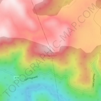
Mount Arrowsmith topographic map
Interactive map
Click on the map to display elevation.
About this map
Name: Mount Arrowsmith topographic map, elevation, terrain.
Location: Mount Arrowsmith, Tasmania, Australia (-42.21053 146.07518 -42.21043 146.07528)
Average elevation: 761 m
Minimum elevation: 459 m
Maximum elevation: 982 m
Other topographic maps
Click on a map to view its topography, its elevation and its terrain.
Cape Naturaliste
Australia > Tasmania > Musselroe Bay
Cape Naturaliste, Forester Kangaroo Drive, Musselroe Bay, Tasmania, Australia
Average elevation: 2 m
Campbell Town
Australia > Tasmania > Campbell Town
Campbell Town, Tasmania, 7210, Australia
Average elevation: 214 m