
Clervaux topographic map
Interactive map
Click on the map to display elevation.
About this map
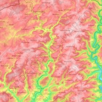
Name: Clervaux topographic map, elevation, terrain.
Location: Clervaux, Canton Clervaux, Luxembourg (49.99886 5.95692 50.13657 6.13796)
Average elevation: 451 m
Minimum elevation: 254 m
Maximum elevation: 546 m
La commune est située dans l’Oesling, la partie luxembourgeoise de l'Ardenne. Des plateaux dégagés, à une altitude moyenne de 500 m, entrecoupés d'étroites vallées, constituent l'essentiel des paysages de la région.
Other topographic maps
Click on a map to view its topography, its elevation and its terrain.
Reuler
Luxembourg > Canton Clervaux > Clervaux
Reuler, Clervaux, Canton Clervaux, 9768, Luxembourg
Average elevation: 456 m
Lieler
Luxembourg > Canton Clervaux > Clervaux > Lieler
Lieler, Clervaux, Canton Clervaux, 9972, Luxembourg
Average elevation: 448 m
Hosingen
Luxembourg > Canton Clervaux > Parc Hosingen
Hosingen, Parc Hosingen, Canton Clervaux, 9806, Luxembourg
Average elevation: 464 m
Weiswampach
Weiswampach, Canton Clervaux, Luxembourg
Average elevation: 475 m
Parc Hosingen
Parc Hosingen, Canton Clervaux, Luxembourg
Average elevation: 417 m