
Fairfield topographic map
Interactive map
Click on the map to display elevation.
About this map
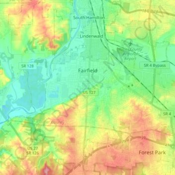
Name: Fairfield topographic map, elevation, terrain.
Location: Fairfield, Comté de Butler, Ohio, États-Unis d'Amérique (39.30147 -84.62992 39.36679 -84.47683)
Average elevation: 213 m
Minimum elevation: 158 m
Maximum elevation: 311 m
Other topographic maps
Click on a map to view its topography, its elevation and its terrain.
Old Ford Canal
États-Unis d'Amérique > Ohio > Comté de Butler > Hamilton
Old Ford Canal, Hamilton, Fairfield Township, Comté de Butler, Ohio, États-Unis d'Amérique
Average elevation: 193 m
Liberty Township
États-Unis d'Amérique > Ohio > Comté de Butler
Liberty Township, Comté de Butler, Ohio, États-Unis d'Amérique
Average elevation: 233 m
Oxford
États-Unis d'Amérique > Ohio > Comté de Butler
Oxford, Oxford Township, Comté de Butler, Ohio, 45056, États-Unis d'Amérique
Average elevation: 279 m