
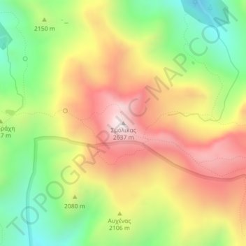
Σμόλικας topographic map
Interactive map
Click on the map to display elevation.
About this map
Name: Σμόλικας topographic map, elevation, terrain.
Average elevation: 2,199 m
Minimum elevation: 1,808 m
Maximum elevation: 2,607 m
Other topographic maps
Click on a map to view its topography, its elevation and its terrain.
Vikos
Greece > Epirus - Western Macedonia > Vikos
Vikos, Zagori Municipality, Ioannina Regional Unit, Epirus Region, Epirus - Western Macedonia, 44016, Greece
Average elevation: 805 m
Μυλάς
Greece > Epirus - Western Macedonia
Μυλάς, Δήμος Γρεβενών, Grevena Regional Unit, West Macedonia Region, Epirus - Western Macedonia, Greece
Average elevation: 1,485 m
Μυλάς
Greece > Epirus - Western Macedonia
Μυλάς, Δήμος Γρεβενών, Grevena Regional Unit, West Macedonia Region, Epirus - Western Macedonia, Greece
Average elevation: 1,454 m
Leptokarya
Greece > Epirus - Western Macedonia > Leptokarya
Leptokarya, Filiates Municipality, Thesprotia Regional Unit, Epirus Region, Epirus - Western Macedonia, 44017, Greece
Average elevation: 148 m