
Isola la Gaiola topographic map
Interactive map
Click on the map to display elevation.
About this map
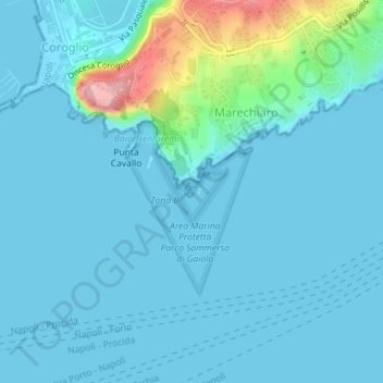
Name: Isola la Gaiola topographic map, elevation, terrain.
Location: Isola la Gaiola, Napoli, NA, CAM, Italia (40.79119 14.18669 40.79201 14.18753)
Average elevation: 19 m
Minimum elevation: -3 m
Maximum elevation: 153 m
Other topographic maps
Click on a map to view its topography, its elevation and its terrain.