
Chale topographic map
Interactive map
Click on the map to display elevation.
About this map
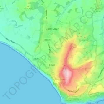
Name: Chale topographic map, elevation, terrain.
Location: Chale, Isle of Wight, Inglaterra, Reino Unido (50.57676 -1.33958 50.63154 -1.29332)
Average elevation: 61 m
Minimum elevation: 0 m
Maximum elevation: 236 m
Other topographic maps
Click on a map to view its topography, its elevation and its terrain.
Ilha de Wight
Reino Unido > Inglaterra > Isle of Wight
Ilha de Wight, Isle of Wight, Inglaterra, Reino Unido
Average elevation: 17 m