
Southend-on-Sea topographic map
Interactive map
Click on the map to display elevation.
About this map
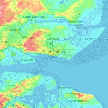
Name: Southend-on-Sea topographic map, elevation, terrain.
Location: Southend-on-Sea, Essex, Inglaterra, SS1 1JX, Reino Unido (51.37882 0.55281 51.69882 0.87281)
Average elevation: 12 m
Minimum elevation: -4 m
Maximum elevation: 96 m
Other topographic maps
Click on a map to view its topography, its elevation and its terrain.
Colchester
Reino Unido > Inglaterra > Essex > Colchester
Colchester, Essex, East of England, Inglaterra, Reino Unido
Average elevation: 28 m
Proverbs Green
Reino Unido > Inglaterra > Essex > Uttlesford > Proverbs Green
Proverbs Green, High Roothing, Uttlesford, Essex, East of England, Inglaterra, CM6 1NF, Reino Unido
Average elevation: 83 m