
Thank you for supporting this site ❤️
Make a donation
Make a donation
Rhodes topographic map
Click on the map to display elevation.
Thank you for supporting this site ❤️
Make a donation
Make a donation
Rhodes
Rhodes is situated 363 km (226 mi) east-southeast from the Greek mainland, and 18 km (11 mi) from the southern shore of Turkey. Mount Attavyros, at 1,216 m (3,990 ft), is the island's highest point of elevation.
Thank you for supporting this site ❤️
Make a donation
Make a donation
About this map
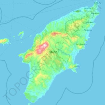
Name: Rhodes topographic map, elevation, terrain.
Location: Rhodes, Aegean, Greece (35.87666 27.68357 36.45828 28.24763)
Average elevation: 67 m
Minimum elevation: 0 m
Maximum elevation: 1,200 m
Thank you for supporting this site ❤️
Make a donation
Make a donation
Other topographic maps
Click on a map to view its topography, its elevation and its terrain.