
Area F (Grindrod/Ashton Creek/Mabel Lake) topographic map
Interactive map
Click on the map to display elevation.
About this map
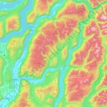
Name: Area F (Grindrod/Ashton Creek/Mabel Lake) topographic map, elevation, terrain.
Average elevation: 1,081 m
Minimum elevation: 341 m
Maximum elevation: 2,664 m
Other topographic maps
Click on a map to view its topography, its elevation and its terrain.
Davis Peak
Canada > British Columbia > Regional District of North Okanagan > Area F (Grindrod/Ashton Creek/Mabel Lake)
Davis Peak, Area F (Grindrod/Ashton Creek/Mabel Lake), Regional District of North Okanagan, British Columbia, Canada
Average elevation: 2,013 m
Cherryville
Canada > British Columbia > Regional District of North Okanagan > Area E (Cherryville/East Creighton) > Cherryville
Cherryville, Area E (Cherryville/East Creighton), Regional District of North Okanagan, British Columbia, V0E 2G3, Canada
Average elevation: 643 m
Enderby
Canada > British Columbia > Regional District of North Okanagan > Enderby > Enderby
Enderby, Regional District of North Okanagan, British Columbia, V0E 1V0, Canada
Average elevation: 511 m