
Thank you for supporting this site ❤️
Make a donation
Make a donation
Katanga topographic map
Click on the map to display elevation.
Thank you for supporting this site ❤️
Make a donation
Make a donation
About this map
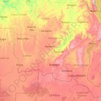
Name: Katanga topographic map, elevation, terrain.
Location: Katanga, Democratic Republic of the Congo (-13.45904 21.75076 -4.99994 30.79625)
Average elevation: 1,008 m
Minimum elevation: 386 m
Maximum elevation: 2,546 m
Thank you for supporting this site ❤️
Make a donation
Make a donation
Other topographic maps
Click on a map to view its topography, its elevation and its terrain.