
Kasai-Oriental topographic map
Interactive map
Click on the map to display elevation.
About this map
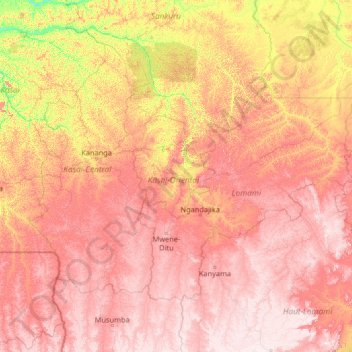
Name: Kasai-Oriental topographic map, elevation, terrain.
Location: Kasai-Oriental, Democratic Republic of the Congo (-8.75363 20.99605 -3.55363 26.19605)
Average elevation: 713 m
Minimum elevation: 359 m
Maximum elevation: 1,170 m
Other topographic maps
Click on a map to view its topography, its elevation and its terrain.
Khartoum
Democratic Republic of the Congo > Kinshasa
Khartoum, Ngiri-Ngiri, Kinshasa, Democratic Republic of the Congo
Average elevation: 297 m
Terrain
Democratic Republic of the Congo > North Kivu > Beni
Terrain, Beni, North Kivu, Democratic Republic of the Congo
Average elevation: 1,084 m
Katanga
Democratic Republic of the Congo
Katanga, Democratic Republic of the Congo
Average elevation: 1,008 m
Bandundu
Democratic Republic of the Congo
Bandundu, Democratic Republic of the Congo
Average elevation: 555 m
Orientale
Democratic Republic of the Congo
Orientale, Democratic Republic of the Congo
Average elevation: 729 m
Mont Amba
Democratic Republic of the Congo > Kinshasa > Mbanza Lemba
Mont Amba, Mbanza Lemba, Lemba, Kinshasa, Democratic Republic of the Congo
Average elevation: 404 m
Kinshasa
Democratic Republic of the Congo > Kinshasa
Kinshasa, Aketi, Kinshasa, Democratic Republic of the Congo
Average elevation: 316 m
Mont Amba
Democratic Republic of the Congo > Kinshasa
Mont Amba, Kinshasa, Democratic Republic of the Congo
Average elevation: 359 m
Lower Uele
Democratic Republic of the Congo > Lower Uele
Lower Uele, Democratic Republic of the Congo
Average elevation: 552 m