Geolocate

Orientale topographic map

Interactive map

Click on the map to display elevation.

About this map

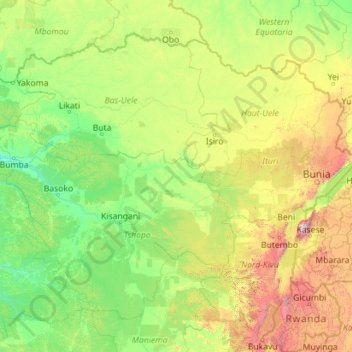
Name: Orientale topographic map, elevation, terrain.

Location: Orientale, Democratic Republic of the Congo (-1.98102 22.26073 5.39200 31.30568)

Average elevation: 729 m

Minimum elevation: 344 m

Maximum elevation: 4,618 m

Other topographic maps

Click on a map to view its topography, its elevation and its terrain.

Khartoum

Democratic Republic of the Congo > Kinshasa

Khartoum, Ngiri-Ngiri, Kinshasa, Democratic Republic of the Congo

Average elevation: 297 m

Terrain

Democratic Republic of the Congo > North Kivu > Beni

Terrain, Beni, North Kivu, Democratic Republic of the Congo

Average elevation: 1,084 m

Kasai-Oriental

Democratic Republic of the Congo

Kasai-Oriental, Democratic Republic of the Congo

Average elevation: 713 m

Katanga

Democratic Republic of the Congo

Katanga, Democratic Republic of the Congo

Average elevation: 1,008 m

Bandundu

Democratic Republic of the Congo

Bandundu, Democratic Republic of the Congo

Average elevation: 555 m

Mont Amba

Democratic Republic of the Congo > Kinshasa > Mbanza Lemba

Mont Amba, Mbanza Lemba, Lemba, Kinshasa, Democratic Republic of the Congo

Average elevation: 404 m

Kinshasa

Democratic Republic of the Congo > Kinshasa

Kinshasa, Aketi, Kinshasa, Democratic Republic of the Congo

Average elevation: 316 m

Mont Amba

Democratic Republic of the Congo > Kinshasa

Mont Amba, Kinshasa, Democratic Republic of the Congo

Average elevation: 359 m

Lower Uele

Democratic Republic of the Congo > Lower Uele

Lower Uele, Democratic Republic of the Congo

Average elevation: 552 m