
Leithagebirge topographic map
Interactive map
Click on the map to display elevation.
About this map
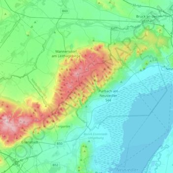
Name: Leithagebirge topographic map, elevation, terrain.
Average elevation: 187 m
Minimum elevation: 110 m
Maximum elevation: 478 m
Other topographic maps
Click on a map to view its topography, its elevation and its terrain.
Neusiedler See
Österreich > Burgenland > Gemeinde Purbach > Florianisiedlung
Neusiedler See, Neubaugasse, Florianisiedlung, Gemeinde Purbach, Bezirk Eisenstadt-Umgebung, Burgenland, 7083, Österreich
Average elevation: 147 m