
How Caple topographic map
Interactive map
Click on the map to display elevation.
About this map
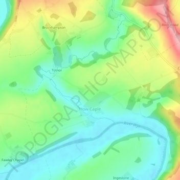
Name: How Caple topographic map, elevation, terrain.
Location: How Caple, Herefordshire, England, United Kingdom (51.96314 -2.59782 51.98421 -2.55152)
Average elevation: 76 m
Minimum elevation: 29 m
Maximum elevation: 161 m
Other topographic maps
Click on a map to view its topography, its elevation and its terrain.
Much Birch
United Kingdom > England > Herefordshire
Much Birch, Herefordshire, England, United Kingdom
Average elevation: 138 m
Garway Hill
United Kingdom > England > Herefordshire > Garway
Garway Hill, Garway, Herefordshire, England, HR2 8RX, United Kingdom
Average elevation: 187 m
Leominster
United Kingdom > England > Herefordshire
Leominster, Herefordshire, England, United Kingdom
Average elevation: 101 m
Symonds Yat East
United Kingdom > England > Herefordshire > Goodrich > Symonds Yat East
Symonds Yat East, Goodrich, Herefordshire, West Midlands, England, HR9 6JL, United Kingdom
Average elevation: 97 m
Sherrington Wood
United Kingdom > England > Herefordshire > Bearwood
Sherrington Wood, Bearwood, Pembridge, Herefordshire, West Midlands, England, United Kingdom
Average elevation: 128 m
Hereford
United Kingdom > England > Herefordshire
Hereford, Herefordshire, England, United Kingdom
Average elevation: 68 m
Bromyard
United Kingdom > England > Herefordshire
Bromyard, Herefordshire, England, HR7 4FA, United Kingdom
Average elevation: 148 m
Hoarwithy
United Kingdom > England > Herefordshire
Hoarwithy, Herefordshire, England, HR2 6QH, United Kingdom
Average elevation: 84 m