
Thank you for supporting this site ❤️
Make a donation
Make a donation
Eagle Rock topographic map
Click on the map to display elevation.
Thank you for supporting this site ❤️
Make a donation
Make a donation
About this map
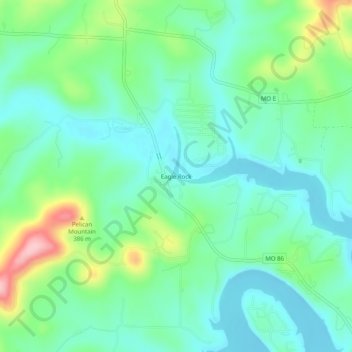
Name: Eagle Rock topographic map, elevation, terrain.
Location: Eagle Rock, Barry County, Missouri, 65641, United States (36.52812 -93.77436 36.56812 -93.73436)
Average elevation: 322 m
Minimum elevation: 276 m
Maximum elevation: 445 m
Thank you for supporting this site ❤️
Make a donation
Make a donation
Other topographic maps
Click on a map to view its topography, its elevation and its terrain.
Thank you for supporting this site ❤️
Make a donation
Make a donation
Purdy
United States > Missouri > Barry County
US Department of the Interior Original Surveys and USGS Topographical map showing the Butterfield Overland Mail Route
Average elevation: 445 m
Purdy
United States > Missouri > Barry County
US Department of the Interior Original Surveys and USGS Topographical map showing the Butterfield Overland Mail Route
Average elevation: 445 m
Thank you for supporting this site ❤️
Make a donation
Make a donation