
Thank you for supporting this site ❤️
Make a donation
Make a donation
Quinto topographic map
Click on the map to display elevation.
Thank you for supporting this site ❤️
Make a donation
Make a donation
About this map
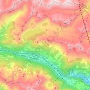
Name: Quinto topographic map, elevation, terrain.
Location: Quinto, Circolo di Quinto, District de Léventine, Tessin, Suisse (46.47458 8.63346 46.57710 8.78523)
Average elevation: 1,932 m
Minimum elevation: 740 m
Maximum elevation: 2,976 m
Thank you for supporting this site ❤️
Make a donation
Make a donation
Other topographic maps
Click on a map to view its topography, its elevation and its terrain.
Thank you for supporting this site ❤️
Make a donation
Make a donation
Thank you for supporting this site ❤️
Make a donation
Make a donation