
Make a donation
Ballater topographic map
Click on the map to display elevation.
Make a donation
Ballater
Ballater (/ˈbælətər/, Scottish Gaelic: Bealadair) is a village in Aberdeenshire, Scotland, on the River Dee, immediately east of the Cairngorm Mountains. Situated at an elevation of 213 metres (699 feet), Ballater is a centre for hikers and known for its spring water, once said to cure scrofula. It is home to more than 1400 inhabitants and has had a long connection with the British royal family.
Make a donation
About this map
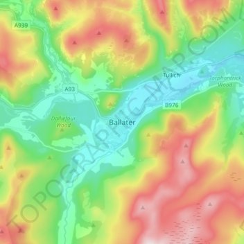
Name: Ballater topographic map, elevation, terrain.
Location: Ballater, Aberdeenshire, Scotland, AB35 5QD, United Kingdom (57.00951 -3.08052 57.08951 -3.00052)
Average elevation: 360 m
Minimum elevation: 184 m
Maximum elevation: 645 m
Make a donation
Other topographic maps
Click on a map to view its topography, its elevation and its terrain.
Chapelton of Elsick
United Kingdom > Scotland > Aberdeenshire
House styles in Chapelton vary from small apartments to five bedroom family homes. The architecture of the houses' exteriors have slate roof tiles and lime harl. Architectural details and materials in the first phase include slate roofs, timber windows (sash and case to public elevations), Dormer|dormer…
Average elevation: 93 m